Transport Zanieczyszczeń w Zlewni

Interdyscyplinarna Grupa Badawcza


Interdyscyplinarna Grupa Badawcza Transport Zanieczyszczeń w Zlewni skupia naukowców z różnych instytucji badawczych współpracujących w zakresie modelowania i analizy transportu zanieczyszczeń odprowadzanych ze zlewni do odbiornika. Za istotne aspekty badań przyjęto określenie stanu jakości środowiska wodnego i rozpoznanie dróg migracji zanieczyszczeń, jak również zagadnienia związane ze spływem powierzchniowym, erozją powierzchniową. Ponadto, w swoich badaniach Grupa Badawcza bierze pod uwagę wpływ zmian środowiskowych, szczególnie zmian klimatu, na wybrane zjawiska zachodzące w zlewni (np. eutrofizację).

Grupa specjalizuje się w analizach z użyciem innowacyjnego Makromodelu DNS/SWAT, który pozwala z dużą precyzją odtworzyć w przestrzeni cyfrowej wybraną zlewnię rzeczną wraz z zachodzącymi na niej procesami.

Makromodel stanowi rodzaj platformy pozwalającej łączyć ze sobą wybrane moduły w zależności od potrzeb, tworząc w ten sposób integralny system zdolny do symulacji obecnych i przyszłych zmian zachodzących w środowisku. Potencjał tego narzędzia jest stale rozwijany, m.in. poprzez implementację wyników z projektów FORECOM, Climate Impact, MPA, oraz łączeniu go z metodą sediment fingerprinting i innymi modelami wykorzystywanymi do opisu na przykład procesów w zbiornikach wodnych.

Do kluczowych zainteresowań Grupy Badawczej należą:

  • Stan jakości osadów wodnych i zawiesiny wodnej z uwzględnieniem stanu ekologicznego cieku/zbiornika wodnego;
  • Procesy hydrochemiczne i geochemiczne zachodzące w systemach rzecznych;
  • Szacowanie ładunku zawiesiny dostarczanej ze zlewni do odbiornika;
  • Wpływ zmian klimatu i użytkowania zlewni na ładunek zawiesiny;
  • Analiza źródeł zawiesiny w zlewni z wykorzystaniem metody znaczników geochemicznych (sediment fingerprinting);
  • Długookresowa migracja metali śladowych w dolinach rzecznych;
  • Rola wód gruntowych w transferze zanieczyszczeń z koryta rzecznego;
  • Akumulacja zanieczyszczeń nieorganicznych i mikroplastików w osadach dennych i zawiesinie wodnej.
  • Tworzenie narzędzi umożliwiających śledzenie transportu (jakościowego i ilościowego) zanieczyszczeń związanych z zawiesiną ;
  • Wyznaczenie stref podatnych na zanieczyszczenie związkami biogennymi z działalności rolniczej;

Skład zespołu

Kierownik

dr hab. inż.

Ewa SzalińskA 

van

  Overdijk


prof. AGH

Członkowie zespołu

dr hab. inż.

Urszula Aleksander-Kwaterczak

prof. AGH

dr inż.

Paulina Orlińska-Woźniak

IMGW-PIB

dr inż.

Paweł Wilk

IMGW-PIB

dr inż.

Monika Szlapa

Politechnika Krakowska

dr hab.

Paweł Hachaj

Politechnika Krakowska

Doktoranci

mgr inż.

Damian Bojanowski

Wybrane publikacje

Climate change impacts on contaminant loads delivered with sediment yields from different land use types in a Carpathian basin.

Science of The Total Environment, 755, 142898.


Szalińska E., Zemełka G., Kryłów M., Orlińska-Woźniak P., Jakusik E., Wilk P., 2021. Climate change impacts on contaminant loads delivered with sediment yields from different land use types in a Carpathian basin, Science of The Total Environment, 755, 142898, https://doi.org/10.1016/j.scitotenv.2020.142898, (IF=6,551; 200 pkt)


Abstract
Soil runoff and sediment transport are considered as an important vector for particle-bound contaminant transfer from source to receiving waters. Under changing climate conditions and rapid basin development, identification of sediment origins is critical for planning further action to reduce erosion effects, and further pollution to surface waters. The goal of this study was to distinguish sediment sources in a Carpathian basin (Wolnica River, southern Poland) and to perform source-oriented contaminant load estimations. Sediment yields (SYLD) and land use specific sediment yields (LUSY) were modeled with the use of the Macromodel DNS/SWAT (Discharge-Nutrients-Sea/Soil and Water Assessment Tool). Sorting of sediment sources was performed by the fingerprinting method using variability of the geochemical composition of soils (Pb, Zn, Cd, Cu, Mn, Ni, Fe, Hg, total N and P, Σ16 PAHs, and 137Cs) of four land use (LU) types: arable lands (A), grasslands (G), residential areas (R), and forests (F). Statistical analysis revealed six metals (Pb, Zn, Cd, Cu, Ni, and Hg) as fingerprint properties providing the best source discrimination in this basin. The contribution of particular land use origin assessed with the use of the mixing model varied in the range of 20–30%. Finally, estimation of land use specific contaminant loads in suspended sediments was performed as a result of a modeling and sediment fingerprinting combination. The final estimates revealed yearly LUSY values varying between 716 t/y for A, 12 t/y for F, and metal loads from 31 kg/y for Zn to values below 100 g/y for Cd and Hg. Long-term predictions (2046–2055) of the metal loads revealed an increase by 75% under the combined RCP 8.5 climate change and land use scenarios. These findings are of great value for land management in the Carpathian basins, especially with regards to the predicted increase of forest cover which significantly alters contaminant signals conveyed through the system.

Multiparameter assessment of select metal distribution in lacustrine sediments.

Journal of Soils and Sediments


Aleksander-Kwaterczak U., Kostka A., Leśniak A., 2021. Multiparameter assessment of select metal distribution in lacustrine sediments. Journal of Soils and Sediments, 21, 1: 512–529; https://doi.org/10.1007/s11368-020-02732-x, (IF= 2,763; 100 pkt)


Abstract
Purpose The main objective of the study was the determination of the Cd, Cr, Cu, Pb, and Zn distribution in Wigry Lake sediments, as well as the contamination and ecotoxicological risk assessment on the basis of a large data set. Materials and methods Select metal concentrations were determined via AAS or ICP-MS. Contamination assessment was achieved via the implementation of different geochemical background values, selected pollution indices, and by way of comparison with the limit values of the sediment quality guidelines and supported by cartographic methods. Results and discussion Metal concentrations presented in the paper were associated with a specific type of sediment and sedimentation environment. The highest concentrations of metals were found in the fluvial-lacustrine sediment covering the bottom of the bay of eutrophic character. The lowest amounts were found in the lacustrine chalk and clastic sediment present in the littoral parts of the lake, while profundal sediments were more enriched with metals. Studies revealed that the examined metals have mostly natural, but also anthropogenic origin. The assessment of lake sediments, with the use of geochemical background values and different indices, yielded highly diversified results associated with the variability of background values applied in the study. However, ultimately, the Wigry Lake sediments were found to be only slightly contaminated with Cd, Cr, Cu, and Zn, while Pb concentrations were considered to be more disturbing. The potential ecotoxicological risk was assessed as low. Conclusions Particular attention in this study was paid to the significance of the geochemical background values adopted for calculations, which, in the case of Wigry Lake, gave very divergent results. A uniquely large data set facilitated the performance of a thorough analysis of metal distributions in recent lacustrine sediments and highlighted the necessity of using integrated approaches in aquatic ecosystem studies.

Sediment load variability in response to climate and land use changes in a Carpathian catchment (Raba River, Poland).

Journal of Soils and Sediments, 20:2641–2652.


Szalińska E., Orlińska-Woźniak P., Wilk P., 2020. Sediment load variability in response to climate and land use changes in a Carpathian catchment (Raba River, Poland). Journal of Soils and Sediments, 20: 2641–2652; https://doi.org/10.1007/s11368-020-02600-8, (IF=2,669; 100 pkt)


Abstract
Purpose This study analyzes the variability of sediment loads under variant climate change and land use scenarios in a Carpathian catchment with a dam reservoir. The areas with the highest share of sediment loads are tracked to establish possible indications for future catchment management plans. Materials and methods 
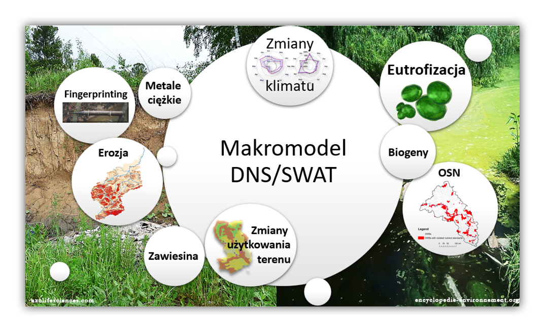
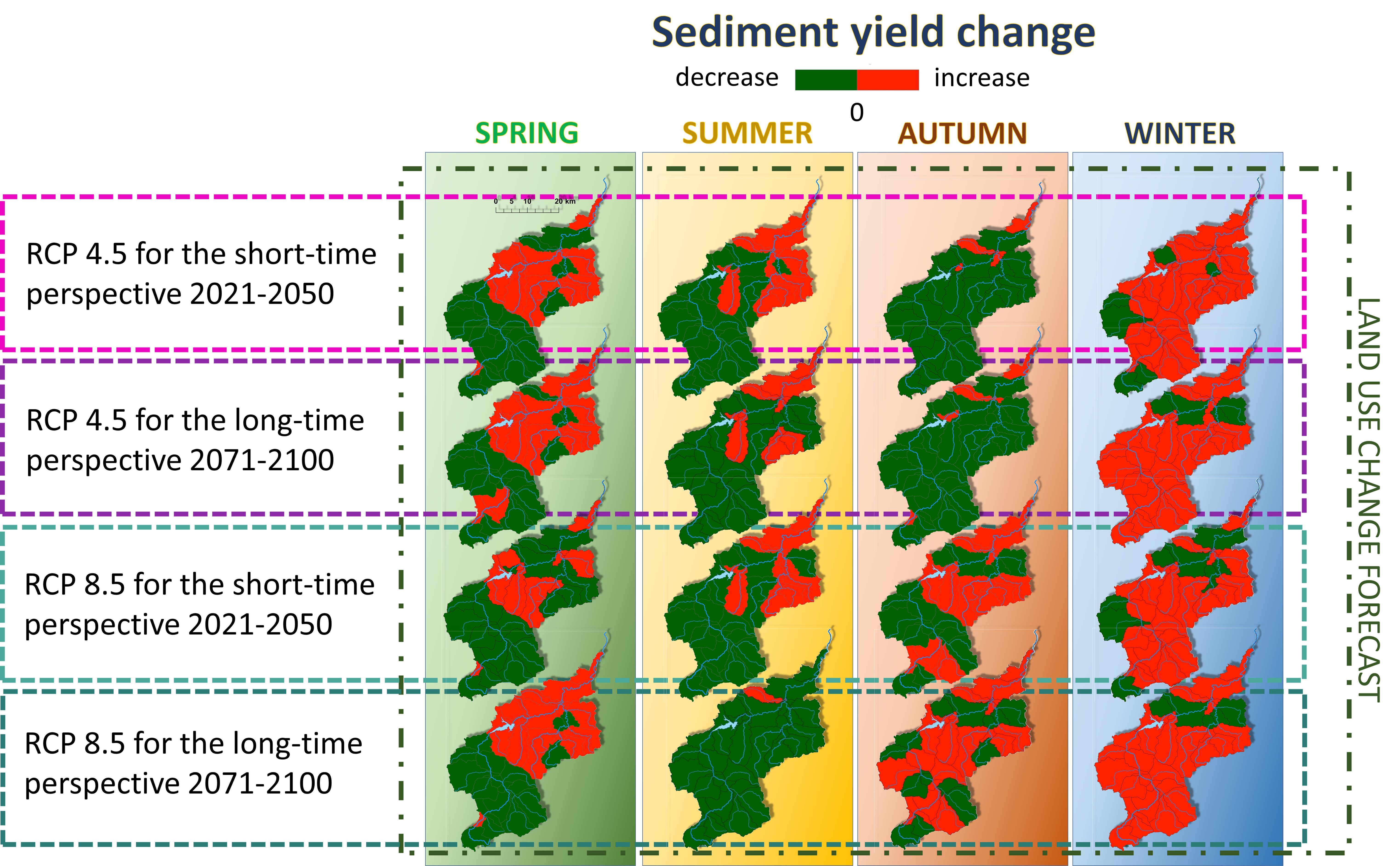
Analyses were performed for the Raba River catchment (Poland, Carpathian Mountains) with use of the Macromodel DNS/SWAT. The RCP 4.5 climate forecast predictions (2021–2050 and 2071–2100), downscaled for the area of Poland, and land use predictions from the DYNA-Clue model for the Carpathian area, were taken into consideration. A total of seven scenarios were created, accounting for precipitation (P1 and P2), temperature (T1 and T2), land use (LU) changes, and combined effects (COMB1 and COMB2). Results and discussion 
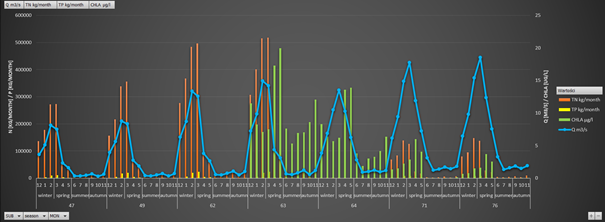
The average load delivered to the dam reservoir was estimated as 2.43 Gg y−1, and its seasonal/yearly variability was followed by local meteorological phenomena. Among the tested factors, precipitation change, in terms of total amount and intensity, exerted the most impact on sediment loads causing their increase. Temperature and land use changes resulted in a slight decrease. Combined scenarios implied that changes of the catchment area use, such as increase of forest cover, can noticeably reduce sediment loads delivered into a dam reservoir. Conclusions The performed simulations revealed the importance of incorporating variant scenarios for catchment management plans, development of land use mitigation measures (erosion), and operational procedures for the dam reservoir. Particular attention should be paid to warmer winters with heavy rainfalls and temperatures above zero, which together with a lack of plant vegetation result in elevated annual sediment loads reaching the dam reservoir. Further changes must be mitigated by anti-erosion investments. Introduction Climate change impact at the catchment scale has been studied intensely over the last 20 years. Multiple publications have reported alterations in flow characteristic, flood event frequency, and snow cover extent (Bussi et al. 2016; Hattermann et al. 2017). Moreover, these alterations are further amplified by shifts in the land use induced by temperature and precipitation changes (Wang et al. 2016; Bussi et al. 2017) or resulting from socio-economic reasons (Grecequet et al. 2017). Since these shifts of water and runoff cycles can severely disturb natural processes like weathering and erosion, changes in sediment fluxes can also be expected (Simonneaux et al. 2015; Yang et al. 2015). Assessment of sediment quantities delivered from a catchment is particularly important for regions that are highly vulnerable to erosion, e.g., mountainous areas with high slopes, and/or intensive and frequent rainfalls. Also, sediment continuity in a majority of these catchments has been obstructed by anthropogenic factors, e.g., alterations to channel morphology, or construction of dams and reservoirs (Apitz 2012; Ahilan et al. 2018). Especially, in the latter case, estimations of the sediment accumulation rate and remaining reservoir capacity are of a crucial significance (Alighalehbabakhani et al. 2017). Current studies related to sediment quantity estimations under climate change scenarios generally predict an increase of sediment loads under an upward trend of average precipitation due to intensification of soil erosion (Lu et al. 2013; Darby et al. 2015; Zhou et al. 2017; Giardino et al. 2018; Barrera Crespo et al. 2019). However, the response in individual catchments can vary due to possible changes in vegetation cover, as a result of water balance changes, reducing erosion in the area. The response of catchment models to temperature changes is even more complex, naturally displaying either an increase or a decrease in sediment loads (Bussi et al. 2016). Since temperature shifts can affect catchment water balance through various local phenomena, e.g., early snowmelt, droughts/rainfall occurrence, and distribution of vegetation cover, their impact on sediment loads seems to be strongly related to catchment geographical settings (Jentsch and Beierkuhnlein 2008; Ricci et al. 2018; Shrestha and Wang 2018). Therefore, to produce reliable predictions, modeling efforts should incorporate results of downscaled climate predictions, account for regional trends in land use change, and analyze them simultaneously (Bussi et al. 2016). 
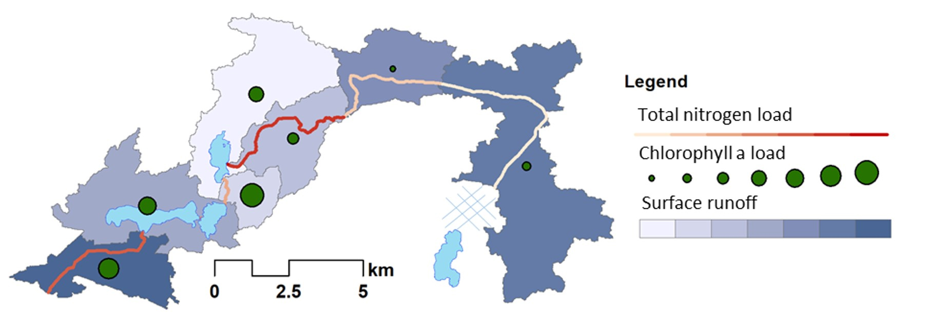
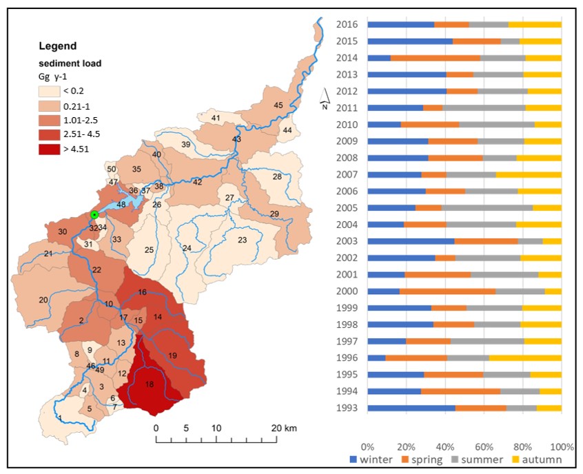
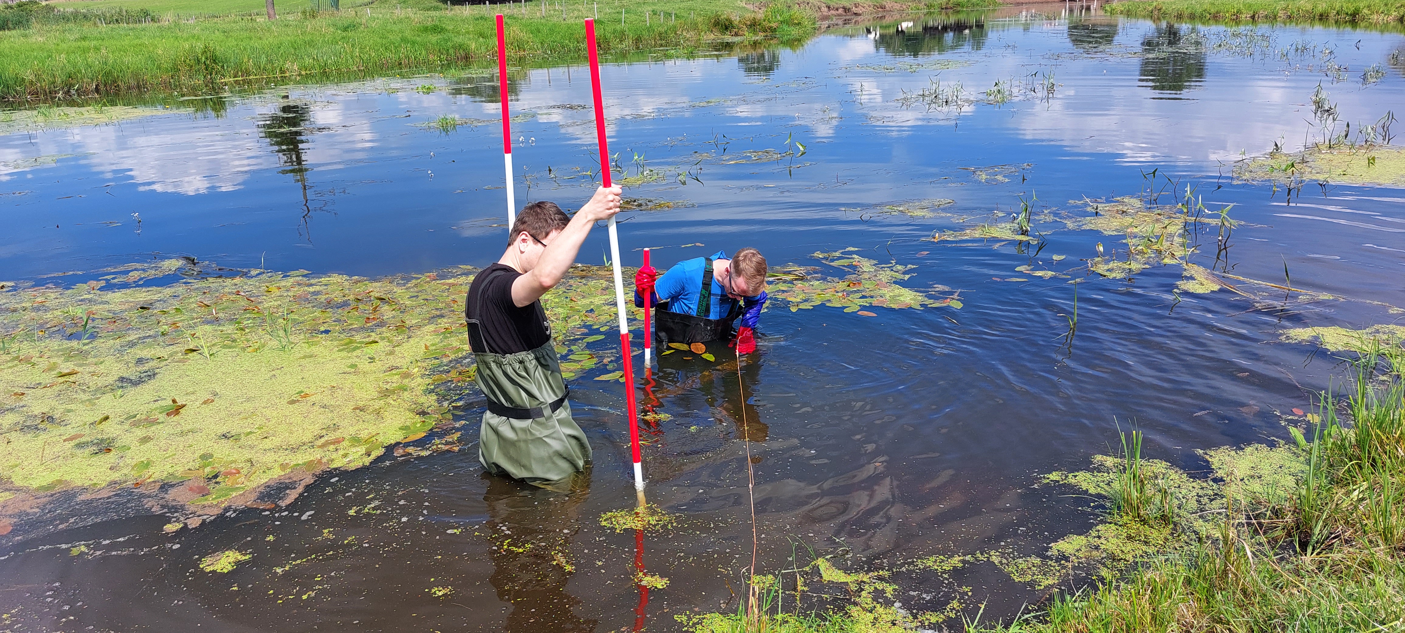
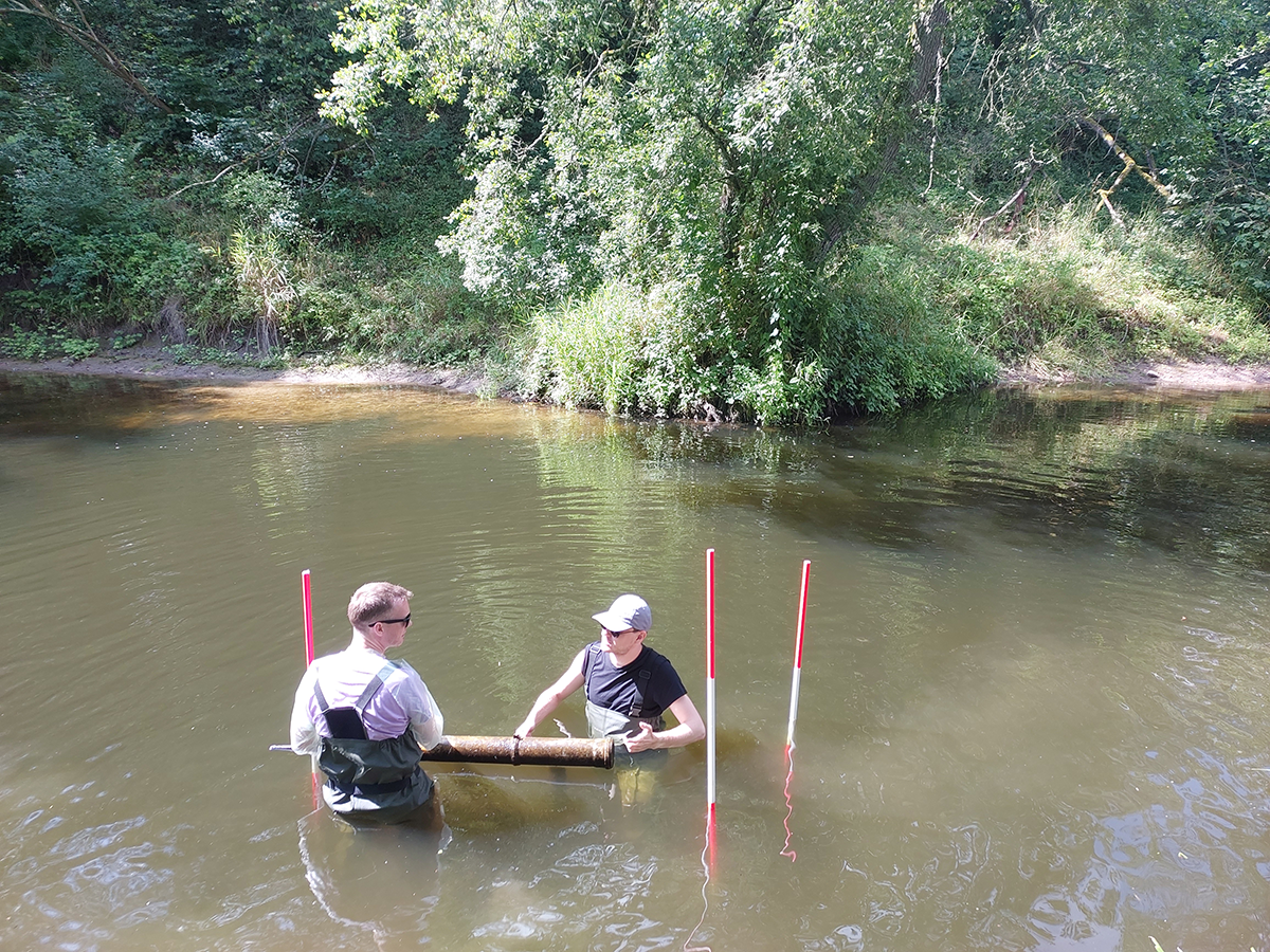
The main goal of the study was to analyze the variability of sediment loads under variant climate change and land use scenarios in a Carpathian catchment with a dam reservoir. The Raba River (southern Poland) has been selected as the study venue, since its catchment represents the most typical conditions for this region. The upper part of this river flows through a mountainous area with a considerable number of agricultural fields. Also, the river features a drinking water dam reservoir, accumulating sediments delivered from the upper part of the catchment. The sediment load variability was tested with use of the Macromodel DNS/SWAT (Discharge-Nutrient-Sea/Soil Water Assessment Tool) under the RCP4.5 climate change predictions, downscaled for the Polish area (Mezghani et al. 2017). To account for local land use changes, the results from the DYNA-Clue (Dynamic Conversion of Land Use and its Effects) model for the area of interest were taken into consideration (Price et al. 2017). Besides tracking the effects of individual precipitation, temperature, and land use changes, the goal of the study was to observe the impact of the combined changes on the sediment loads. Delimitation of the sub-catchments with the highest portion of sediment loads delivered to the reservoir was tracked to establish possible indications for future catchment management plans.

Land use changes balance out sediment yields under climate change predictions on the subbasin scale? The Carpathian basin as an example.

Water, 12(5), 1499


Orlińska-Woźniak P., Szalińska E., Wilk P., 2020. Land use changes balance out sediment yields under climate change predictions on the subbasin scale? The Carpathian basin as an example. Water, 12(5), 1499; https://doi.org/10.3390/w12051499, (IF=2,524; 70 pkt)


Abstract
The issue of whether land use changes will balance out sediment yields induced by climate predictions was assessed for a Carpathian basin (Raba River, Poland). This discussion was based on the Macromodel DNS (Discharge–Nutrient–Sea)/SWAT (Soil and Water Assessment Tool) results for the RCP 4.5 and RCP 8.5 scenarios and LU predictions. To track sediment yield responses on the sub-basin level the studied area was divided into 36 units. The response of individual sub-basins to climate scenarios created a mosaic of negative and positive sediment yield changes in comparison to the baseline scenario. Then, overlapped forest and agricultural areas change indicated those sub-basins where sediment yields could be balanced out or not. The model revealed that sediment yields could be altered even by 49% in the selected upper sub-basins during the spring-summer months, while for the lower sub-basins the predicted changes will be less effective (3% on average). Moreover, the winter period, which needs to be re-defined due to an exceptional occurrence of frost and snow cover protecting soils against erosion, will significantly alter the soil particle transfer among the seasons. Finally, it has been shown that modeling of sediment transport, based on averaged meteorological values and LU changes, can lead to significant errors.


The river absorption capacity determination as a tool to evaluate state of surface water. Hydrology and Earth System.

Sciences, 22(2), 1033-1050


Wilk, P., Orlińska-Woźniak, P., Gębala, J., 2018. The river absorption capacity determination as a tool to evaluate state of surface water. Hydrology and Earth System Sciences, 22(2), 1033-1050. https://doi.org/10.5194/hess-22-1033-2018 , (IF=5,15; 140 pkt)


Abstract
In order to complete a thorough and systematic assessment of water quality, it is useful to measure the absorption capacity of a river. Absorption capacity is understood as a pollution load introduced into river water that will not cause permanent and irreversible changes in the aquatic ecosystem and will not cause a change in the classification of water quality in the river profile. In order to implement the method, the Macromodel DNS/SWAT basin for the Middle Warta pilot (central Poland) was used to simulate nutrient loads. This enabled detailed analysis of water quality in each water body and the assessment of the size of the absorption capacity parameter, which allows the determination of how much pollution can be added to the river without compromising its quality class. Positive values of the calculated absorption capacity parameter mean that it is assumed that the ecosystem is adjusted in such a way that it can eliminate pollution loads through a number of self-purification processes. Negative values indicate that the load limit has been exceeded, and too much pollution has been introduced into the ecosystem for it to be able to deal with through the processes of self-purification. Absorption capacity thus enables the connection of environmental standards of water quality and water quality management plans in order to meet these standards.


Delimitation of nutrient vulnerable zones - a comprehensive method to manage a persistent problem of agriculture.

Agricultural Systems, 183, 102858.


Orlińska-Woźniak P., Wilk P., Szalińska E., 2020. Delimitation of nutrient vulnerable zones - a comprehensive method to manage a persistent problem of agriculture. Agricultural Systems, 183, 102858; https://doi.org/10.1016/j.agsy.2020.102858, (IF=4,131; 140 pkt)


Abstract
Agriculture, despite numerous efforts, still remains the key pressure on the aquatic environment causing an over excessive enrichment with nitrogen and phosphorus compounds. Therefore, an essential part of contemporary research and management endeavours to identify areas at risk. Presented here is a method of delimitation of such zones susceptible to nutrient pollution from agricultural activities. The starting point for its development, and subsequent construction, was the problem of Nitrate Vulnerable Zones of agricultural origin (NVZ), which still, as of yet, has not been resolved within the European Union. Surface component of NVZ (s-NVZ) areas have served as an example of a method application in a pilot catchment of the Warta River, which is one of the largest river catchments in Poland. The proposed method employs a mathematical algorithm using catchment modeling. The methods rely on a multi-stage delimitation procedure, which allows for precise delineation of only those areas within the catchment, which actually contribute to the analyzed problem (nutrient pollution and eutrophication). The method enables the user to benefit from a very extensive database, which can be modified in almost any way, depending on the current needs and local circumstances. It is also possible to expand this tools possibilities, connecting and coupling the used Macromodel with other modules or models. The proposed method can also be applied by countries that have recognized their whole territory as an NVZ area to designate areas particularly exposed to pollution (i.e. hot-spots). The proposed method applied for the pilot catchment resulted in an indication of 14 s-NVZs, occupying over 6800 km2 in total (13% of the catchment area). The indicated areas have been confirmed to have the largest share of agricultural pollution discharge into surface waters.

Metal mobility in a mine-affected floodplain.

Minerals, 10(9), 814


Ciszewski D., Aleksander-Kwaterczak U., 2020. Metal mobility in a mine-affected floodplain. Minerals, 10(9), 814; https://doi.org/10.3390/min10090814, (IF=2,380; 100 pkt)


Abstract
The study attempted to map and predict the remobilization of metals in a floodplain which had been heavily affected by long-term Zn–Pb mining. This research, based on Zn, Cd, Pb, Ca and Fe speciation, mineralogy and the stratigraphy of sediments which had accumulated over the distance of a dozen or so km from the mine, revealed variable potential for metal mobilization. The results suggest that a drop in the water table, something to be expected after the closure of a mine, would be accompanied by a decrease in the pH of the river water and can induce the remobilization of metals associated with carbonates and exchangeable cations over the short-reach downstream of the mine. However, the mobilization of contaminants may be impeded by the alkaline, impermeable stratum of loams, which play a pivotal role in maintaining anaerobic conditions and buffering the acidity resulting from the partial degradation of sulfides. Based on the findings of the study, it can be expected that the intrinsic attenuation will limit the need for remediation works, although monitoring river water quality is recommended to determine the need for any intervention in cases where permissible quality values have been exceeded over a longer period. Results of this research can be useful as a reference for remediation works planned in other contaminated river systems experiencing water table lowering, where the mobilization of contaminants as a consequence of sediment oxidization can be expected.

BIOMASS PRODUCTION POTENTIAL IN A RIVER UNDER CLIMATE CHANGE SCENARIOS

Environmental Science and Technology


Orlińska-Woźniak, P., Szalińska, E., Jakusik, E., Bojanowski, D., & Wilk, P. (2021). Biomass Production Potential in a River under Climate Change Scenarios. Environmental science & technology. 55, 16, 11113–11124 https://doi.org/10.1021/acs.est.1c03211, (IF=9.028; 140 pkt)


Abstract
Excessive production of biomass, in times of intensification of agriculture and climate change, is again becoming one of the biggest environmental issues. Identification of sources and effects of this phenomenon in a river catchment in the space–time continuum has been supported by advanced environmental modules combined on a digital platform (Macromodel DNS/SWAT). This tool enabled the simulation of nutrient loads and chlorophyll “a” for the Nielba River catchment (central-western Poland) for the biomass production potential (defined here as a TN:TP ratio) analysis. Major differences have been observed between sections of the Nielba River with low biomass production in the upper part, controlled by TN:TP ratios over 65, and high chlorophyll “a” concentrations in the lower part, affected by biomass transport for the flow-through lakes. Under the long and short-term RCP4.5 and RCP8.5 climate change scenarios, this pattern will be emphasized. The obtained results showed that unfavorable biomass production potential will be maintained in the upper riverine sections due to a further increase in phosphorus loads induced by precipitation growth. Precipitation alone will increase biomass production, while precipitation combined with temperature can even enhance this production in the existing hot spots.

ESTIMATION OF NUTRIENT LOADS WITH THE USE OF MASS BALANCE AND MODELLING APPROACHES ON THE WEŁNA RIVER CATCHMENT EXAMPLE (CENTRAL POLAND)

Scientific Reports, 12:13052.


Bojanowski D., Orlińska-Woźniak P., Wilk P., Szalińska E. 2021. Estimation of nutrient loads with the use of mass‑balance and modelling approaches on the Wełna River catchment example (central Poland), Scientific Reports, 12:13052; https://doi.org/10.1038/s41598-022-17270-4, (IF= 4.996; 140 pkt)


Abstract
Nitrogen and phosphorus budgeting is considered to be a key tool for policy makers and stakeholders when dealing with nutrient contamination issues, however no unified method has been employed in countries affected by this eutrophication problem. The current study offers a detailed insight into the estimations of nutrient loads and their distribution between different sources for a middle-sized agricultural catchment, with the use of two approaches: mass balance (static) and modelling (dynamic). Both methods revealed similar contributions of analysed nutrient sources, although the final estimates in the chosen calculation profile were divergent due to the various reasons related to the methods’ specificity. The advantages and disadvantages of both approaches have been specified in our study, and a hybrid solution on a local and country wide scale has been proposed.

EXPANDING THE SEDIMENT TRANSPORT TRACKING POSSIBILITIES IN A RIVER BASIN THROUGH THE DEVELOPMENT OF A DIGITAL PLATFORM—DNS/SWAT

Applied Sciences, 12(8), 3848.


Wilk, P. (2022). Expanding the Sediment Transport Tracking Possibilities in a River Basin through the Development of a Digital Platform—DNS/SWAT. Applied Sciences, 12(8), 3848. https://doi.org/10.3390/app12083848, (IF= 2.838; 100 pkt)


Abstract
Simulation of stochastic and variable sediment transport processes within models still poses a big challenge, especially in mountainous areas. Since sediment transport, including erosion and deposition, remains an unceasing problem in many areas, sediment modeling is perceived as a possible solution. This article combines a review of the selected sediment models with a presentation of the effects of several years of research using the DNS digital platform in the Western Carpathians. The review focuses on the main advantages and gaps in selected modeling tools with particular emphasis on one of the most popular: SWAT. The description of the digital platform—DNS is an example of how to answer these gaps by combining subsequent models, methods, and databases using their best features. To accentuate the benefits of such an approach, the effects of combining subsequent models (AdH/PTM) and methods (fingerprinting) on a common digital DNS space are presented, on the example of the Raba River (basin). In this way, both unique possibilities of estimating the amount of contamination carried with sediment particles and their sources, as well as sequencing of sedimentation in the reservoir, taking into account its subsequent zones, were obtained.

MODELING CHLOROPHYLL A WITH USE OF THE SWAT TOOL FOR THE NIELBA RIVER (WEST-CENTRAL POLAND) AS AN EXAMPLE OF AN UNMONITORED WATERCOURSE

WATER, 14(10), 1528.


Orlińska-Woźniak, P. (2022). Modeling Chlorophyll a with Use of the SWAT Tool for the Nielba River (West-Central Poland) as an Example of an Unmonitored Watercourse. Water, 14(10), 1528. https://doi.org/10.3390/w14101528, (IF= 3.530; 100 pkt)


Abstract
The majority of eutrophication studies focuses on lacustrine processes, thus riverine systems remain less recognized in this context. Moreover, since the availability of data related to parameters affecting this phenomenon is quite limited, modeling efforts should be considered. The current study verifies the SWAT model’s capability to simulate chlorophyll a loads for unmonitored watercourse. The analyses of the relationships between individual parameters, directly involved in the eutrophication process, help in the exploration of its dominant trends in SWAT modeling. The results obtained for the Nielba River pilot catchment (west-central Poland) showed a strong correlation of chlorophyll a with flow and surface runoff, but no relationship with temperature or solar radiation. Moreover, an impact of local conditions (hydrological features) on chlorophyll a load simulation could be traced in detail. The research specified the limitations and impact of generalization in the SWAT model on the results. Furthermore, intricacies related to the dataset statistical treatment (e.g., outliers) have been presented.

FROM THE SOURCE TO THE RESERVOIR AND BEYOND-TRACKING SEDIMENT PARTICLES WITH MODELING TOOLS UNDER CLIMATE CHANGE PREDICTIONS (CARPATHIAN MTS.).

Journal of Soils and Sediments, 14(10), 1528.


Wilk P., Szlapa M., Hachaj P. S., Orlińska-Woźniak P., Jakusik E., & Szalińska, E. (2022). From the source to the reservoir and beyond-tracking sediment particles with modeling tools under climate change predictions (Carpathian Mts.). Journal of Soils and Sediments https://doi.org/10.1007/s11368-022-03287-9, (IF= 3.308; 100 pkt)


Abstract
Purpose The study tracks spatial and temporal distribution of sediment particles from their source to the deposition area in a dammed reservoir. This is particularly important due to the predicted future climate changes, which will increase the severity of problems with sediment transport, especially in catchments prone to erosion. Methods Analyses were performed with a monthly step for two mineral and one mineral/organic sediment fractions delivered from the Carpathian Mts. catchment (Raba River) to the drinking water reservoir (Dobczyce) by combining SWAT (Soil and Water Assessment Tool), and AdH/PTM (Adaptive Hydraulics Model/Particle Tracking Model) modules on the digital platform—Macromodel DNS (Discharge Nutrient Sea).To take into account future changes in this catchment, a variant scenario analysis including RCP (representative concentration pathways) 4.5 and 8.5, and land use change forecasts, was performed. Results The differences between the two analyzed hydrological units (catchment and reservoir) have been highlighted and showed a large variability of the sediment load between months. The predicted climate changes will cause a significant increase of mineral fraction loads (silt and clay) during months with high flows. Due to the location and natural arrangement of the reservoir, silt particles will mainly affect faster loss of the first two reservoir zones capacities. Conclusions The increased mobility of finer particles (clay) in the reservoir may be more problematic in the future, mainly due to their binding pollutant properties, and the possible negative impact on drinkingwater abstraction from the last reservoir zone. Moreover, the study shows that the monthly approach to forecasting the impact of climate change on sediment loads in the reservoir is recommended, instead of a seasonal one.

Bazy danych / Database

A DATABASE FOR A SEDIMENT YIELD ANALYSIS IN THE RABA RIVER BASIN (CARPATHIAN MTS).

https://data.mendeley.com/datasets/rft94c75zb/3


Paulina Orlińska-Woźniak, Ewa Szalinska, Paweł Wilk, DOI: 10.17632/rft94c75zb.3


A DATABASE FOR NUTRIENTS AND CHLOROPHYLL ‘A’ IN THE NIELBA RIVER (POLAND).

https://data.mendeley.com/datasets/mpfyk7jcz9/2


Paulina Orlińska-Woźniak, Ewa Szalińska van Overdijk, Paweł Wilk, DOI: 10.17632/mpfyk7jcz9.2


SEDIMENT PARTICLE DISTRIBUTION IN A DAMMED RESERVOIR UNDER CLIMATE AND LAND USE SCENARIOS (CARPATHIAN MTS.).

https://data.mendeley.com/datasets/k9c7c666bt/1


Paweł S. Hachaj, Monika Szlapa, Paulina Orlińska-Woźniak, Ewa Jakusik, Paweł Wilk, Ewa Szalińska, DOI: 10.17632/k9c7c666bt.1


DATA FOR: DELIMITATION OF NUTRIENT THREATENED AREAS - A COMPREHENSIVE METHOD TO MANAGE A PERSISTENT PROBLEM OF AGRICULTURE.

https://data.mendeley.com/datasets/rn8j755vdd/1


Paulina Orlińska-Woźniak, Ewa Szalinska, Paweł Wilk, DOI: 10.17632/rn8j755vdd.1


AGH Akademia Górniczo-Hutnicza
im. Stanisława Staszica w Krakowie
IMGW Instytut Meteorologii i Gospodarki Wodnej -
Państwowy Instytut Badawczy
PK Politechnika Krakowska
im. Tadeusza Kościuszki
 
WGGiOŚ - AGH Wydział Geologii, Geofizyki i Ochrony Środowiska - AGH
KOŚ Katedra Ochrony Środowiska
Wydział Geologii, Geofizyki i Ochrony Środowiska - AGH
WISiE Wydział Inżynierii Środowiska i Energetyki Politechniki Krakowskiej
KGiGW Katedra Geoinżynierii i Gospodarki Wodnej
Wydział Inżynierii Środowiska i Energetyki Politechniki Krakowskiej